Many people associate the South Urals with heavy industry and gloomy mountain ranges. But behind the feigned severity of these places, there is an amazing flora and fauna, fragile nature and ancient history. Chelyabinsk Region is a land of surreal landscapes and beautiful legends.
Leaving the city limits, you find yourself in completely wild places. Some points in the region look the same as millions of years ago. Caves that keep the traces of primitive people, volcanoes that have fallen asleep forever and reservoirs shrouded in superstition - the Chelyabinsk region has something to be proud of. The local nature is original and rebellious, and its solid character evokes respect and delight among the guests of the region.
The most interesting natural monuments in the region
List, photos with names and descriptions of places worth visiting!
Lake Turgoyak
Tourists call the lake the Chelyabinsk Riviera - white sand and clear water make it similar to a popular resort. Turgoyak is deep - 34 meters, it warms up badly in summer. This does not interfere with vacationers, there are many tourist centers and sanatoriums on the shores. There are a dozen islands in the lake, some of which have preserved archaeological sites. You can get to them by renting a boat, but you have to row with oars - motorized water transport is prohibited here.

Arakul Shihan
A favorite gathering place for climbers in the north of the region is the famous Shikhan. From the top of high granite rocks 2 km long, a magnificent panorama of the network of Ural lakes opens up. And at the very foot of the Shikhan there is a fish lake Arakul. The mountain range is interesting not only for its landscapes - archaeologists have discovered traces of our ancestors here. The purpose of the strange stone depressions in the rocks has not been established to this day.

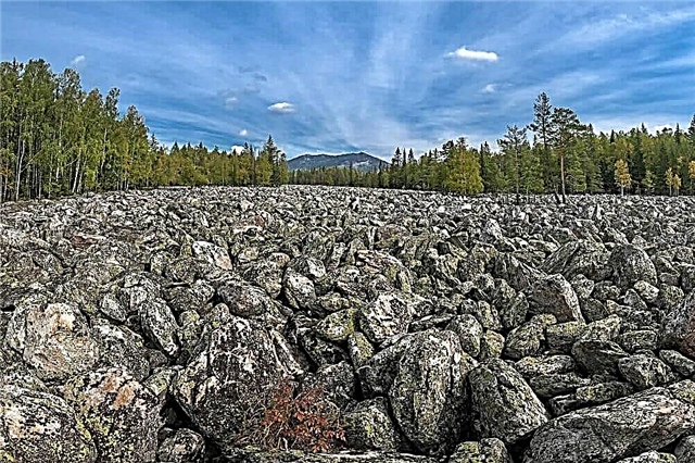
Taganay stone river
Near Mount Sredniy Taganay there is a place called the Stone River. The peculiarity of this six-kilometer river is that stones play the role of water. Scientists explain the formation of the stone "stream" by the melting of the glacier in ancient times. If you listen carefully, under the pile of stones you can find the flow of real water - mountain streams rustle. The stones of the amazing river are also difficult - most of them are semi-precious aventurine.

Dry Atya Cave
One of the longest and deepest caves in the region, it is popular with tourists. But it's better to explore it in clothes, which are not a pity to throw away later. The lowest point of the cave is at a depth of 75 meters. The grottoes and labyrinths are full of mud puddles and whole rivers of clay. And the name “Sukha Atya” contradicting this fact was given to the underground cavity in honor of the village of the same name, which is located nearby.

Megaliths of Vera Island
On one of the islands of Lake Turgoyak, there are very ancient and significant buildings for historians - the famous megaliths. They are believed to have been created about 6 thousand years ago. Scientists claim that the megaliths were built for a religious purpose - rituals and sacrifices were held here. Astronomical calculations were involved in the construction. Similar finds have been found throughout the entire territory of Vera Island.

Damn stone
Mount Yurma in the Urals is not loved by the locals - it is credited with witchcraft properties and generally advise tourists not to go to its surroundings. But to the Devil's Stone or, as the travelers called it, the Devil's Gate, only 985 meters rise. And you should definitely see this monument. Quartzite gates look menacing and majestic - it's hard to believe that they were created by nature and not by man.

Ignatievskaya cave
7 km from the village of Serpievka there is a cave that attracts visitors not only with its historical value, but also with legends. During the excursion, tourists are given the chance to get acquainted with the rock art of the Paleolithic era. Believers come here to see the face of the Mother of God emerging on the rock. It is believed that a blue-blooded hermit monk lived here. The total length of the cave is 545 meters, and there are a lot of sights on each segment of the path.

Zyuratkul fountain
Near Mount Bolshoy Uvan, a ten-meter fountain gushes straight from the ground. In severe frost, its jets freeze in outlandish forms, so it is more advisable to visit this object in winter. The appearance of the Zyuratkul fountain is an accident. A well drilled by geologists threw out a powerful stream of water, beating for almost half a century. A small river took its source from here, the banks of which were gradually overgrown with recreation areas.

Lake Arakul
The best view of Arakul is from the top of Shikhan. The lake is small, only 3 km², but rich in fish. In the last century, there was even a fish breeding station here. Arakul takes into its waters the currents of the Olkhovka and Kaganka rivers, and gives life to the small river Arakulka. Swimming here is not very convenient - the shores are rocky, there are many wetlands. But there are also cozy backwaters where you can camp and contemplate the mountain ranges hanging over Arakul.

Kiselevskaya cave
5 km from the city of Asha, near the Kiselevsky brook, there is a signpost - it is easy to navigate along it where the entrance to the cave is. To walk through the underground halls, you will need equipment and experience in rock climbing - the descent into the cave is vertical. The total length of all passages is more than a kilometer, so it is better to take a guide with you. Of interest are the calcite formations in grottoes and the wintering grounds for bats.

Lake Itkul
The transparent, but very cold lake beckons not only with sandy-stone beaches and pine thickets on the shores. Of the abundance of local archaeological sites, Shaitan-Kamen is the most valued. On a block sticking out of the water in the old days they sacrificed to the gods. Fishermen love Itkul - fishing is always a success here. Tourists set up tent camps or settle in coastal villages - Itkul and Dautovo.

Ustinovsky canyon
An irreplaceable source of food for the ancient man, the Ustinovsky Canyon, fed our great-grandfathers. Tortured by the chase, the animal fell into a 20-meter abyss, and the hunter had only to go down for the carcass. Until now, researchers continue to find the remains of animals and traces of the life of cavemen in the nearby grottoes. The limestone cliffs hanging over the Miass River are more than 300 million years old.

Mount Izvoz
Overgrown with a pine forest, a rocky mountain 3 km from Verkhneuralsk is very curious if you look at it from a bird's eye view. Green spaces form the name of the leader of the proletariat - and this is not a freak of nature. The word "Lenin" was planted from fir trees back in the 70s. To the top 527 meters, once there was a small church. Today it has been restored.

Mount Kosotur
The history of the city of Zlatoust begins from this mountain - the first settlements began to be built at its foot, which eventually turned into a city. The height of the hill is 586 meters, from the side of the Ai river the slope is rocky and steep. The northern slope is cut by clean springs. The mountain is located within the city limits, but the view from the top is not inferior to virgin landscapes. All Chrysostom - at a glance.

Kurgazak cave
The unique glacier cave on the left bank of the Ai River is not the easiest location for a beginner in mountaineering. Its length is slightly more than half a kilometer, but narrow passages covered with eternal ice, high slopes require care and attention. In summer, it is humid inside due to the thawing of the glacier. The most convenient way to get acquainted with the karst cave is while rafting down the Ai River.

Tyulyuk river
Previously, in the tributary of the Yuryuzan River, they were engaged in fishing and rafting. Now the most high-mountainous river in the region is under protection, and serves only as an interesting object for tourists. All 25 km of length are suitable for water sports - rough currents and shallow depths are ideal for sport rafting.Tuluk originates from the swamp of the same name, where cranberries grow abundantly.

Mount Kruglitsa
At a distance of 15 km from Zlatoust, a view of the most impressive mountain of the Taganay massif opens. It was called a round face for a round top. The height of the mountain is 1178 meters. Locals believe that the mountain is moving - such a mirage can really be seen on a sunny day. The reason for this is the evaporation of the marshes at the foot. Quartzite rock is also considered a "place of power". And those who believe in this come here to practice meditation.

Sanctuary on the lake Big Allaki
Not far from the town of Kasli there is a picturesque lake, and on its southeastern shore there are hills of unusual shape. These amazing rocks are the remains of an ancient sanctuary. The most valuable archaeological finds in these places date back to the Paleolithic era. The rocks are decorated with bizarre letters, partially destroyed by vandals even before the sanctuary became a natural monument.

Responsive comb
After Mount Kruglitsa, the Otkliknoy Ridge is the highest point of the Taganai massif. Its height is 1155 meters, the ridge includes quartzite, mica, staurolite and aventurine, which is often found in the Urals. The interesting name is associated with the polyphonic echo that occurs here in connection with the shape of the rock. There are tourist camps at the foot of the Otklikny Ridge. It is quite possible to overcome the ascent and descent in one day, having managed to enjoy the panorama from the top.

Simskiy pond
The pond of the city Sim, descended from the pages of fairy tales, amazes with its beauty. Here, wildlife coexists in tandem with human activities. On the one hand - a modern city, on the other - pine-covered hills and sheer cliffs, 9 meters of transparent depth. For local vacationers and tourists a full range of services - coastal entertainment, boat rental, fishing. Or just a photo session with one of the two local dams in the background.

Blue Stone
This rock near the Ural River really has a bluish color, and the reason for this is the predominance of hematite in the rock. The Blue Mountain rises about 60 meters above the small village of Kizilskoye. About 350 million years ago, there was a volcano on the site of the hill, and the Blue Stone is all that remains of it. From a distance, in clear weather, the former volcano looks purple, which attracts tourists and photographers.

Asha river
From the Karatau ridge to the waters of the Sim River, the beautiful Asha flows, overcoming mountains and forests on its way. The rugged mountain river is one of the cleanest in the region. There are several large settlements on the banks of the Asha, and in the river basin there are countless limestone caves that are interesting to visit. The length of the river is 59 km; rare birds and animals can be found near the water. But swimming in the icy Asha is not recommended.

Dry land of the Sim river
Nature has endowed the Sim River with an amazing property - to hide from human eyes. In the upper reaches, the river completely disappears under the stones and reappears near the entrance to the Ignatievskaya cave. Thus, Sim shortens the road, not bothering to bend around the Serpievsky cave castle. The river flows underground for more than half a kilometer.

Sugomak cave
The striking marble cave in Mount Sugomak admits only hardened tourists into its bowels. To fully explore the dungeon, you need special equipment. There are only three grottoes, one of them is half filled with water. And under it, the Sugomakskaya cave keeps unexplored passages and corridors. The length of the cave is 123 meters, unauthorized entry into it is prohibited.

Lake Smolino
The mysterious lake in Chelyabinsk has an extensive biography. During its existence, it both overflowed and became shallow. At the moment, Smolino reaches 7 meters in depth, the salt water is becoming more fresh. The coast is inhabited - there are dacha villages and recreation centers. People come to be treated with lake mud and look at the archaeological sites of the Stone Age in the vicinity.

Kashtak forest
An island of nature near the noisy Chelyabinsk - Kashtak pine forest. It is about 6 km from the city to get here, the territory of the protected forest park is 1543 hectares. Bor is famous for rare species of plants and animals. Vacationers visit this place not only to have a picnic on the Miass River. Bor is used by cyclists for outdoor activities, and the presence of rocks attracts climbers.

Bolshaya Satka River
This changeable river carries its waters 88 km from Zyuratkul to the Ai River. At first, calm and measured, further downstream - rapids. Rafters often float along it, making halts near the camps of primitive man. There are several of these along the entire length of the river. Those who are interested in looking at the first hydroelectric power plant in Russia also come - it appeared here at the beginning of the 20th century.

Dzhabyk-Karagai forest
About 100 thousand hectares of relict forests of the Urals have been carefully protected by the state since 1969. Some areas have survived from the Ice Age, and are a picture of the forests that existed at that time throughout the present territory of the Urals. In the Dzhabyk-Karagai pine forest there are several reservoirs and mountain heights, there are endangered species of animals.

Geological outcrops of mudstones
An unusual 80-meter-high rock rises right above the crushed stone factory of the city of Minyar. This is a unique monument from a geological point of view - a place where mudstones or petrified clay emerge on the surface. Limestones of pink and white colors look very impressive and arouse constant interest among site visitors.

Linden Mountain
Not far from Minyar, in the area of the city of Asha, there is a small Linden Mountain. Its height is only 299 meters, but the age of the mountain is indicated by completely different numbers. The limestones of the upland date back to the Paleozoic era! The name of the mountain comes from the ancient lindens growing on the northern side - some of them are more than a century old. It is this site that is most valued, therefore the mountain is considered a botanical natural monument.